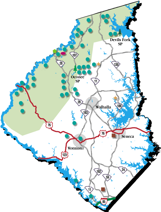
Upstate Parks:The majority of state park trails are considered nature/walking trails because of short length and/or relatively flat terrain. The 14-mile Table Rock trail is difficult terrain and the 15-mile Kings Mountain trail is moderate. Other trails are located at Caesars Head, Jones Gap, Paris Mountain, Oconee and Keowee-Toxaway State Parks. Shorter nature trails located at Croft, Sadlers Creek and Lake Hartwell State Parks. Call the park or S.C. State Parks at (803) 734-0156. Each park offers different camping opportunities from primitive camping to RV hookups. Check with the park you are interested in to learn more about what camping options are available. Also look at some of the links under the about our area section to see some of the adventures others have had enjoying the great outdoors Lake Keowee and Lake Jocassee have to offer. |
|||||||||||||||||||||||||||||||||||||||||||||||||||||||||||||||||||||||||||||||||||||||||||||||||
 |
 |
||||||||||||||||||||||||||||||||||||||||||||||||||||||||||||||||||||||||||||||||||||||||||||||||
Trails around Jocasseeü Lower Whitewater Falls Trail (flows in Jocassee) ü Upper Whitewater Falls Trail (flows into Lower Whitewater Falls) ü Oconee Bell Nature Trail (Trail is slightly inland) ü Bear Cove Trail (Parts of hike is along lake) ü Coon Branch Trail (Will see Whitewater River which flows into Jocassee) ü Laurel Fork Falls Great Waterfall Hikesü Riley Moore Waterfalls ü Yellow Branch Falls Trail ü Horsepasture Wild and Scenic River from Gorges State Park ü Big Bend Trail ü Brasstown Falls ü Opossum Creek Falls Trail ü Long Creek Falls Chattooga Trail and Surrounding Trailsü Chattooga Trail ü East Fork Trail ü Fork Mountain Trail ü Big Bend Trail ü Foothills Trail Table Rock State Parkü Table Rock Trail, Pinnacle Mountain Trail and Carrick Trail Other Great Trailsü Chau Ram County Park L ü Sandy Ford ü Woodall Shoals ü Bull Sluice ü Tennessee Rock Trail (in Georgia) ü Whiteside Mountain. Good Hikes for Familiesü Sand Ford ü Upper Whitewater Falls ü Horsepasture Wild and Scenic River from Gorges State Park ü Brasstown Falls ü Long Creek Falls ü Sliding Rock Trails around JocasseeLower Whitewater FallsDescription: There are six different whitewater waterfalls along the North and South Carolina border. These waterfalls are the highest series of waterfalls in eastern North America. Lower Falls make a 200-foot drop; the water then flows into Lake Jocassee. From the parking area, a hike of 45 minutes to an hour will get you to an overlook where you’ll find a spectacular view of Lower Whitewater Falls. Length of hike: 2.5 miles Difficulty: Moderate Directions to falls:
Upper Whitewater FallsDescription: This waterfall is the largest in the Eastern United States; it is well worth your time to visit. There are several different places where you can observe this waterfall; however, it is a very steep descent to the lower levels to view the waterfall. Directions: There are two ways to get here. A) a small hike, B) a longer hike connecting Lower and Upper Falls. A) a small hike
B) Longer hike connecting Lower and Upper Falls
Difficulty: A) Easy B) Moderate Coon Branch TrailDescription: If leaving from the parking area at the Bad Creek Project you will enter the foothills tails which begins at the parking area. Follow this trail until just before the bridge over the Whitewater River, turn left onto the out and back Coon Branch Trail. This trail will take you trough some dense forests of old hardwoods and rhododendron, you will pass over five bridges. There is the possibility of seeing raccoons and beaver in the wet areas, but other animals such as bobcats, feral hogs, white-tailed deer, and black bear also live in the area. Also, at the top of the ridge you can look out onto the flat and see Lake Jocassee. This trail connects to Lower Whitewater Falls trail via the Foothills trail. Length: 0.9 mile plus 0.5 mile on the Foothills Trail Directions: (see Lower Whitewater Falls Trail directions) Bear CoveFeatures: Here you can find scenic views of Lake Jocassee while hiking through mixed forests. Flowers: See endangered Oconee Bells wildflowers blossom along the creek. Description: This loop trail is marked by white blazes. There are benches placed throughout the loop that you will be able to rest at. This dirt trail is well kept. Difficulty: Easy Length: 3mile loop. Directions: From Seneca where 123 intersects 28 travel North on SC28 towards Walhalla for 5.7 miles. Then take Hwy 11 cutoff just past McDonalds. Follow this until it takes you to a stop sign. Then turn right onto Hwy 11. Follow for and turn left onto Lake Jocassee Rd. Continue to Devil’s Fork State Park. Turn left at the camping area gate then turn right at the first drive. The trail kiosk is on the parking loop. The Oconee Bell trail is a relatively easy trail that features a rare flower called the Oconee Bell. This 1 mile loop also contains benches to relax and a small pond. This trail is located near the entrance of the Park. This trail does not take you along the waterfront. Laurel Fork FallsDescription: This beautiful waterfalls spills 80 feet directly into Lake Jocassee and is best accessed via boat. The alternative option is an eight miles hike-one way via the foothills trail. There is a public landing just off Hwy 11 onto Lake Jocassee. Directions:
Great Waterfall HikesName: Riley Moore Falls Description: This trails’ main feature is a 12-foot high, 50 foot wide waterfall on the Chauga River. This short hike is well worth your time if you are into waterfalls. It is also not unusual to see Otters playing in the river downstream from the falls. Length of hike: 1 mile Difficulty: Moderate Flowers: Clusters of daisy fleabane and fern, plus numerous azaleas Directions to the falls:
Yellow Branch Falls TrailLength: 1.5 Miles one way Difficulty: Moderate Description: To reach these falls you must start off from the Yellow Branch Nature Trail, it will lead you directly to the yellow branch falls trail which will take you to your final destination; the falls. These falls are a popular choice by many to visit. Features: Yellow Branch Waterfall, deep ravines, hardwood forests and finally creek bottoms. Directions: From Seneca take SC 28 to Walhalla and from Walhalla continue on SC 28 for 6.8 miles. You will then turn left into Yellow Branch Picnic Ground (open 6 a.m. to 10 p.m. year round).
Horsepasture Wild and Scenic River from Gorges State ParkLength: 2 miles (one way) Difficulty: Easy to Moderate Description: The hike will begin in the Gorges State Park. This particular trail offers you the chance to see Drift Falls, Turtleback Falls, Rainbow Falls and Stairway Falls. To get to Drift Falls travel from the trailhead 0.7 miles to the river. Then head right for 0.1 miles and you will see the falls. To reach Turtleback falls follow the trailhead 0.7 miles to the river. Then go left and the falls will be downstream 0.03 miles. Then to get to rainbow falls travel downstream from Turtleback Falls another 0.15 miles. To reach Starway Falls you must hike 1 mile downstream from Rainbow Falls. Directions: From Seneca follow 130 until the North Carolina boarder, when you cross the boarder the Rd changes to 281, follow this road until Gorges State Park. Turn in and Park. ****Great Choice for those who love Waterfalls, you can see 4 waterfalls all within 3 mile round trip**** Big Bend TrailLength: 2.7 miles (one way) plus another half mile hike if you wish you wish to see Big Bend Falls Difficulty: Moderate Description: This trail will take you through a hard wood forest and eventually lead you to the Chattooga Trail. If you have the desire to see Big Bend Falls you must hike south on the Chattooga Trail. The falls are a short 15 minute hike from the Chattooga Trail. Directions: From Seneca take SC 28 through Walhalla. Continue on SC 28 until SC 107. You will veer right onto SC 107. Drive on SC 107 until the Cherry Hill Recreation Area on the right. The trailhead is just south of the recreation area entrance.
Brasstown FallsDescription: At the Southern edge of the Sumter National Forest is where you’ll find this great trail. The falls here plummet at three different locations totaling a 120 foot drop. Moreover, these falls are located in a secluded location in Brasstown Valley. This is a great place for a family hike because of the moderate, 20-minute hike as well as there is a swimming hole at the base of the upper falls. Length of hike: 0.25 mile Approximate time to hike: 20 minutes to the bottom of the lower falls Difficulty: Moderate Directions to the falls:
Opossum Creek Falls TrailDescription: The majority of this trail you will be walking along an old forest service trail shaded by a wide variety of hardwoods. Once at the Chattooga River the trail will become more challenging as you will be walking through a heavily vegetated path and walking on and around rocks and trees for a little while before you reach the base of the falls.Total Length of hike: 1.5 miles to the Chattooga River. Another 0.5 mile up Opossum Creek Approximate time to hike: 2 hours Flowers: Wildflowers and lush ferns Difficulty: Difficult Directions to the falls:
Long Creek FallsDescription: These falls have a lot to offer however there are no permanent markings on the trail because the trail is not an official Forest Service trail. These falls have a multi level drop off that spans over 50-feet. Once at the falls, you will be able to swim. You can also enjoy the view after a moderate, hour-long hike.Length of hike: Approximately 1.6 miles Time to hike: 1 hour Difficulty: Difficult Directions to the falls:
Chattooga Trail and Surrounding TrailsChattooga TrailDifficulty: Moderate Length: 15 miles one way Description: This trail follows the Chattooga River and offers hikers excellent views of the scenic river. The trail also takes the hiker by 5 waterfalls, most notably Spoonauger Falls and Big Bend Falls. For parts of this trail you will be on the foothills trail and eventually this trail leads into Bad Creek Trail. Again this trail is good for either hikers or backpackers. Directions: To South end To North end
East Fork TrailLength: 2.5 Miles one way Difficulty: Easy Description: Beginning at the fish hatchery, this trail will link up with the Chattooga trail after 2.5 miles. You have two options, one is to hike back the way you came or the alternative option is to look at the map and decide on a route that suites you the best. During your hike you will travel through East Fork Gorge, once through this you will have scenic wilderness views for the rest of the way. Directions: From Seneca take 28SC to Walhalla and follow this road until SC 107. You will bear right onto SC 107. Then drive until you reach Fish Hatchery Road (Oconee County S-37-325) turn left. The east trailhead is at a bridge just past the Fish Hatchery and picnic area.
Fork Mountain TrailLength: 6.5 miles one way Difficulty: Moderate Description: This lightly traveled trail connects to the Bad Creek Trail which then becomes the Chattooga Trail. Most of this trail is through dense brush and wilderness so the majority of the path is shaded. Also this trail will take you through ravines and a few coves. Directions: From Seneca take SC 28 through Walhalla. Then look for SC 107, bear right onto SC 107. Continue on SC 107 for 15 miles to the junction of Oconee County S-37-413. The Sloan Bridge Picnic Area is approximately .5 miles ahead on the left. From the parking lot, walk north across the highway culvert that crosses East Fork Creek.
Big Bend TrailLength: 2.7 miles (one way) plus another half mile walk if you wish you wish to see Big Bend Falls Difficulty: Moderate Description: This trail will take you through a hard wood forest and eventually lead you to the Chattooga Trail. If you have the desire to see Big Bend Falls you must hike south on the Chattooga Trail. The falls are a short 15 minute hike from the Chattooga Trail. Directions: From Seneca take SC 28 through Walhalla. Continue on SC 28 until SC 107. You will veer right onto SC 107. Drive on SC 107 until the Cherry Hill Recreation Area on the right. The trailhead is just south of the recreation area entrance.
The Foothills TrailName: The Foothills Trail Total Length: 80 Miles Description: The foothills trail is a long and strenuous trail that will take you through the dense forests of North and South Carolina. This trail has over 200 miles of connector trails. Along this trail you will see everything from wildlife to waterfalls. There are plenty of areas to camp along this trail making it ideal for backpackers. If you just wish to go on a hike, there are various access points that will allow you to do so. Flowers: Oconee Bell (Jocassee Gorge only), Pinxter, Dwarf Iris, Rhododendrons, Mountain Laurel Difficulty: Hard Directions: From Seneca take 123 to Walhalla; then drive northwest on SC 28 until you make a right onto SC 107. The entrance to Oconee State Park will then be on your right in a few miles. You will approach a Fee Station, when you reach this turn right and drive to a small parking area. The trailhead for the Foothills Access Trail is at the Foothills Trail sign. There is also an entrance point at the Bad Creek Project. (see directions to Lower Whitewater Falls). Table Rock State Park TrailsTrails in Table Rock State ParkDescription: These intertwined trails take you along several different parts of Table Rock Park. All trails are very well marked so you will not get lost! The Pinnacle Mountain trail will take you to the pretty Mill Creek Falls. This is a moderately difficult trail which happens to connect to the Foothills trail. This trail is 3.3 miles one way, so plan on making this a long trip especially if you plan taking Ridge trail to table rock to get back. The elevation at the top of Pinnacle Mountain is 3,425ft. However, for being the highest point in the park the view is somewhat disappointing. Carrick Creek trail is a lot shorter as it is mile and a half loop. This trail will provide you with the chance to see several small waterfalls and take you through a forest with the chance of seeing wildlife. This hike is fairly easy. The first waterfall you come to has an inviting pool at its base. There several different places along this trail where you will cross a rock path over the stream. Table Rock Trail is a difficult 2.5 mile trek one way. Allow for at least 4 hours to complete the hike. You will climb more than 2000ft to the summit where you will find trickling water down the mountains sheer southeastern face. The trail then travels to the rocky northern face where you will have an incredible view of Caesar’s Head, Mount Pisgah and the Blue Ridge Parkway. This trail is the most difficult Directions: From Seneca travel on SC 28 towards Walhalla for 5.7 miles. Turn right onto the highway 11 cutoff; follow until you reach a stop sign. Turn right and follow Hwy 11 for about 31 miles until you see signs indicating the parks entrance to the left. (This will be West Gate Rd.) Then turn left when you reach Park Rd. Follow this road until you arrive at the Nature Centre. There will be parking available across from the Nature Centre. Other Great TrailsChau Ram County ParkDirections: From Seneca drive west on US 76. Keep right at the fork with US 123 and drive another 2.5 miles. Turn left onto Chau Ram Park Road and continue to the park entrance at the end of the road. Length of Trail- There are several different trail lengths here ranging from 0.2 miles to 1.2 mile long trail. Approx. 4 miles total Difficulty: Moderate/Difficult-Upper Loop, Lower Loop Spur Trail, Moderate-Lower Loop, Upper Connecter Easy-Middle Loop and Old Scout Cabin Features: this steep, rugged trail offers views of hillsides, ridges, and rocky banks along the Chauga River. Sandy FordDescription: This trail will take you across several foot-bridges over cool mountain streams, amid hardwood, pine, and cedar. There is a possibility you may see deer, snakes, and other wildlife. Pets are permitted. There are places where you are able to swim if you please. This is a very short and fairly easy trail. Flowers: Rhododendron and fern Length: .3-mile one-way. Directions: From Seneca take 123 to SC 28 through Walhalla; turn left onto Whetstone Road (193). Drive 5 miles and cross Chattooga Ridge Road (196) where Whetstone becomes Earls Ford Road. Drive 3 more miles and turn left onto FS road 721A. Drive another 1.5 miles. The trail is on the left in the parking area at the end of the road. (This narrow and winding dirt road may especially difficult in wet weather.) Woodall ShoalsDescription: Taking this trail will take you through lush green forest. There will be a steep descent to the river’s edge where rushing water fills a cool mountain pool. You may encounter birds, deer, snakes and other wildlife. Pets are permitted on this particular trail. Length: .2-mile one-way. Cost: $3 per vehicle. Directions: From Seneca, drive northwest on US 76 and turn left onto Orchard Road (Oconee County S37538). Then turn right onto Woodall Shoals Road (FS 757), and drive 2 miles on the dirt road. (The narrow road may be slippery in wet weather.) The parking area is at the end of the road.
Bull SluiceDescription: This trail provides a paved route to flat water or a moderately gravel path to the Bull Sluice rapids rushing over boulders. You may encounter a several species of birds, deer, and possibly a snake throughout this hike. After approximately 100 yards, you can turn left and descend on the paved trail to the sandy, rocky riverbank, or you can turn right and follow the rugged gravel trail along the mountainside to a wooden railing overlooking the rapids. The trail is not maintained beyond this point. Pets are permitted. Length: 0.2-mile one-way. Directions: From Seneca, drive northwest on US 76 until you reach the trailhead that is on the right just before the Chattooga River at the Georgia border.
Tennessee Rock Trail (in Georgia)Length: 2.2 Mile Loop Difficulty: Moderate Description: This is a popular trail since there is much to see especially in the fall when the leaves are in the midst of changing color. A round trip would take roughly an hour. Features: Wildflowers, including lady slippers and umbrella leaf. Black Rock Mountain (3,640 feet) has a boulder field that contains herbs, such as blue cohosh, that are indicative of moist, high elevations. Directions: From Seneca take highway 76 out of Seneca and follow until Highway 23. Head North until you reach Mountain City then turn left onto Black Rock Mountain Parkway
Whiteside Mountain TrailDescription: Whiteside Mountain will offer you one of the best views this area has to offer. The summit of the mountain reaches an elevation of 4900ft. and along this trail you will be able to see in the North Shortoff and Yellow Mountain, Chimneytop Mountain to the East, to the South Lake Keowee, foothills and Piedmont. To the West you will see Nantahala Mountain where the Appalachian Trail roams. While overlooking the cliffs keep an eye out for peregrine falcons. These amazing birds will astonish you as you watch them soar through the air. As you begin to descend back down the Mountain you will find overlooks that will give you amazing views of drop offs of around 750 ft. Difficulty: Moderate Length: 2 Mile Loop Directions: From Seneca drive North on SC 28 towards Walhalla for 5.7 miles. Take the Hwy 11 cut-off on the right just after the McDonalds. This will lead you to a stop sign where you will turn right onto Hwy 11. Drive for 13.1 miles and turn left onto Hwy 130. Follow 130 about 9 miles until you see a sign “to Hwy 107.” You will veer off to the left. Follow this road until a stop sign. You will turn right and now you are on Hwy 107. Follow 107 for about 13 miles until you reach a set of stop lights in Cashiers. Turn right towards Highland onto Hwy. 64. On the Jackson/Macon county line you should see a large green state sign directing the way to Whiteside Mountain. Just past the Jackson/Macon county line turn onto Whiteside Mountain Rd (SR# 1690). Then travel 1 mile to the marked parking area. Here you will encounter a $2.00 fee.
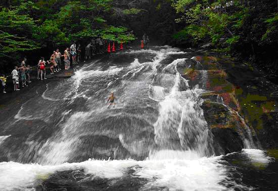
Good Hikes for FamiliesSliding RockDescription: Sliding Rock is an excellent destination for people of all ages since it is just a short easy walk from the parking area. Sliding Rock is a popular hang-out during the summer months for visitors as it offers a 60 foot natural rock waterslide into a cool mountain pool. The drop from the waterslide into the foot is about seven feet. You can either test out the slide yourself, or you can watch other from an observation deck. Sliding rock also offers many great places to have picnics and sunbath. There is a $1 per person fee. Difficulty: Easy Directions: From Seneca drive North on SC 28 towards Walhalla for 5.7 miles. Take the Hwy 11 cut-off on the right just after the McDonalds. This will lead you to a stop sign where you will turn right onto Hwy 11. Drive for 13.1 miles and turn left onto Hwy 130. Follow 130 about 9 miles until you see a sign “to Hwy 107.” You will veer off to the left. Follow this road until a stop sign. You will turn right and now you are on Hwy 107. Follow 107 for about 10 miles until you reach Whiteside Cove Road (SR#1107). Go 2.6 miles to the bridge. There will be a small parking area on the right beyond this road.
For more detailed information visit South Carolina Parks Caesars Head State ParkTopActivities:
Croft State Natural AreaTopActivities:
Devils Fork State ParkTopActivities:
Jones Gap State Park TopTopActivities:
Oconee State ParkTopActivities:
Paris Mountain TopTop Activities:
Keowee-Toxaway State Natural AreaTop Activities:
Lake Hartwell State Recreation AreaTop Activities:
Oconee Station State Historic SiteTop Activities:
Rose Hill Plantation State Historic SiteTop Activities:
Sadlers Creek State Recreation AreaTop Activities:
Table Rock State ParkTop Activities:
Park uk replica watches Tao Fenuo series of new watches We can see in the rolex replica watches crown position to increase the time of a single-button device, usually the timing of the uk replica watches is in the two o'clock and four o'clock position respectively have the start and zero press the button
Appalachian Trail Foothills Trail Contact: |
|||||||||||||||||||||||||||||||||||||||||||||||||||||||||||||||||||||||||||||||||||||||||||||||||
|